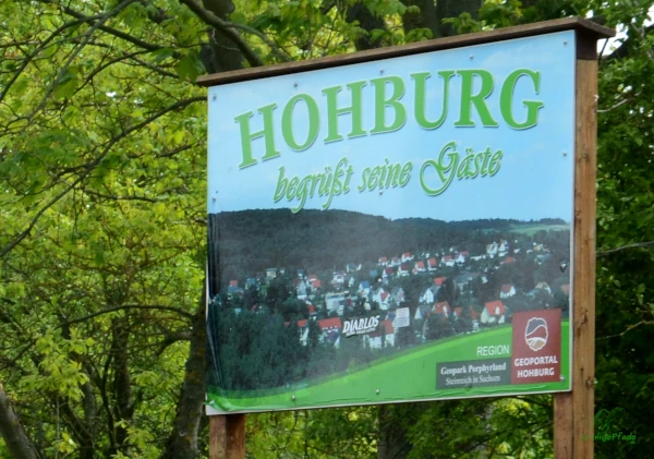
Especially for residents and guests of the east german city Leipzig and the surrounding area in Saxony, the Hohburg Hills are a quickly accessible excursion destination. With the Leipzig City-train S3 to Wurzen, this mountain range can be easily targeted by bicycle. Hohburg, the small village is reached after a short bike ride of about 8 km on separate bike paths through a varied landscape. The Hohburg hills are located about 35 km east of Leipzig and 7 km east of the Mulde river. The so-called „Hohburg Switzerland“ is therefore an obvious option for hiking in the vicinity of Leipzig.

Hiking between quarries and glacial striations
The Hohburg hills are not spectacular, but pleasant and varied. The name „Hohburg Switzerland“ is a bit exaggerated. With an average altitude of about 120m above sea level of the landscape, the hills near Hohburg with 204 to 240m protrude only 80 to 120m from the surroundings. But the versatility makes the mountain range interesting for excursions. Rock formations and quarries, varied forests, the valley of the Lossa creek and the kaolin lake always offer surprises to the visitor’s eye. In addition, the museum Steinarbeiter Haus (Stone Workers House) in Hohburg offers a small insight into the use of natural resources of the region.
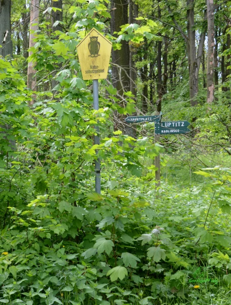
From the Wurzen train station, the journey to Hohburg Switzerland is made by bicycle via Lüptitz. Already on the way there, a small detour at the northern city limits of Wurzen can make the heart of nature lovers beat faster. Especially on warm summer and autumn days, the small nature reserve on the Spitzberg forms a gem in the open landscape. Crickets chirp, kestrels hunt over the spacious meadows and meadow flowers and thistles bloom everywhere. On the northern edge of the former Red Army training area, the Spitzberg appears as a reddish-brown rocky outcrop in the warming rays of the sun.
Behind Lüptitz under the railroad bridge the cycle path leads on the „Alte Hohburger Landstraße“ (Old Hohburg Road) in the direction of Hohburg. Still before the village comes with the „Kleiner Berg“ (Little Hill) another natural treasure of the region. The hilltop of the „Kleiner Berg“ has been a nature reserve since 1976 and is home to dormouse, greater mouse-eared bat and pug bat in the oak and hornbeam forests. But not only flora and fauna are worth protecting here – also geologically the Kleine Berg south of Hohburg is a geologically valuable testimony.
Volcanic rock – rock from the new red conglomerate
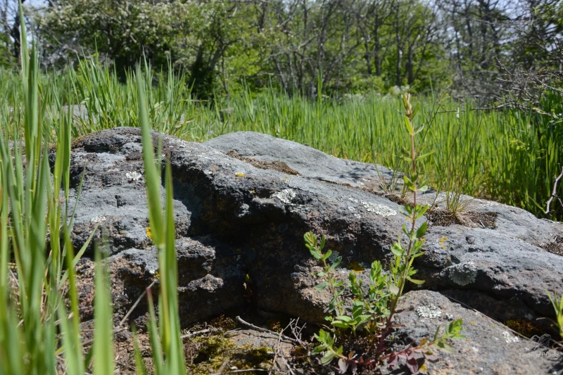
The Hohburg mountains were formed by volcanic eruptions 270 to 240 million years ago, the new red conglomerate. Thus they belong to the northwest Saxonian volcanic complex. Weathering-resistant blankets of quartz porphyry form today’s hilltops of the Hohburg Mountains. Due to the ice ages, which began about 2.6 million years ago, the mountains of volcanic origin were „overformed“ – the glaciers of several cold periods slid over them.
Therefore, at the Kleiner Berg (Little Hill) near Hohburg, so-called glacial striations can be found – exposed porphyry slabs, which show clear grinding traces of the ice-age glaciers. These were discovered and interpreted in 1844 by the Saxon geologist Carl Friedrich Naumann, thus substantiating the theory of inland glaciation.
Glacial sanding and wind corrasion
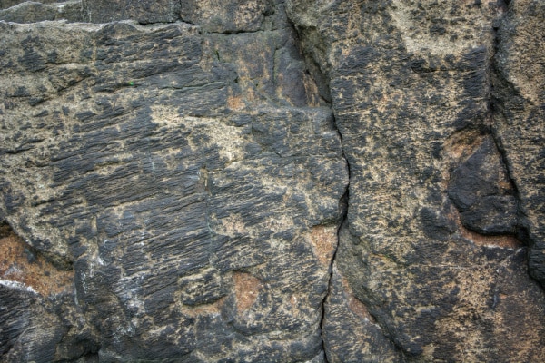
During the Vistula glacial period, another phenomenon will provide lasting traces: Constant strong wind from the southwest provides with silt particles for a natural „sandblast – blower“ and leaves on the southeast located Naumann- Heim-rock for grinding marks – the so-called Windcorrasion.
Thus alone the small mountain south of Hohburg already holds geological testimonies, a varied forest landscape with at present much dead wood, which forms partially regular wood sculptures as well as a multiform flora, as it is not to be found in forests used for forestry. From the heights of the southwestern slope a wide view into the landscape is possible – back to Wurzen with the twin towers of the cake company and into the valley of the Mulde. Evidence of human settlement can also be found in the remains of ramparts of a castle from Slavic times. It is therefore worthwhile to take advantage of the many paths over the Kleiner Berg and hike along it.
Weathered rock from the Tertiary period – the Kaolin Lake
With a small detour from the bike path at the Kleiner Berg you come directly to the Kaolinsee (Kaolin lake), even before you have reached Hohburg. The signposted path branches off to the west and leaves the Kleiner Berg via a serpentine. A modern bridge crosses the narrow connecting channel between the large and small kaolin lakes.
Kaolin is a high-quality very light clay, which was formed in the warm period of the Tertiary from 65 million to the beginning of the ice ages 2.6 million years ago by weathering of little resistant porphyry rocks. From 1900 to 1965 kaolin was extracted in an open pit mine near Hohburg. The mine that was left behind filled up with water and today forms a popular recreational area with the Kaolin Lake. Swimming is possible on the western shore (at your own risk), and a sunbathing lawn a little away from the parking lot (with a modern public restroom) allows for relaxed recreation. However, parents should take care of their children – especially non-swimmers. The shores of the Kaolin lake are relatively steep and also partly slippery due to the slippery clay.

Hohburg – Between hills in the Lossa valley
The name „Hohburg Switzerland“ is certainly a result of the view of the village. Despite the comparatively low mountain heights, the location of Hohburg in the narrow valley of the Lossa – stream between the Kleiner Berg in the south and the mountain range in the north looks a bit like a secluded, dreamy mountain village. Especially when viewed from the west. And such a shielding from the noise and pulse of modernity by timeless and constant mountain ranges awakens soothing feelings of security in many.
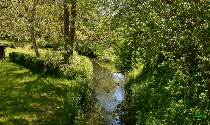
Along the course of the Lossa stream it is also really nice and green, ducks swim on the stream, a small dammed pond reinforces the village idyll.
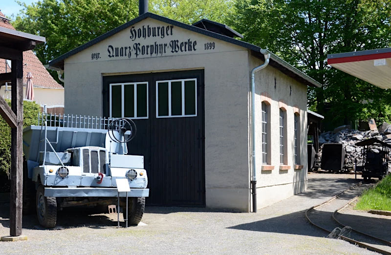
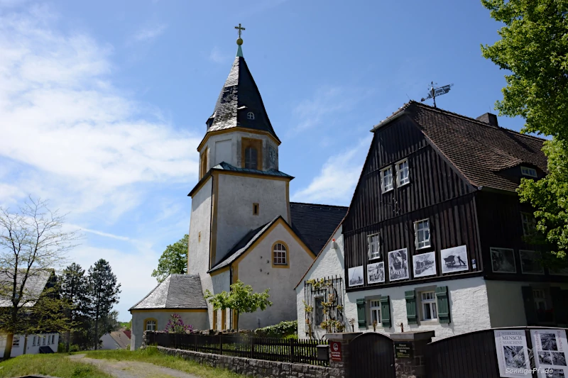
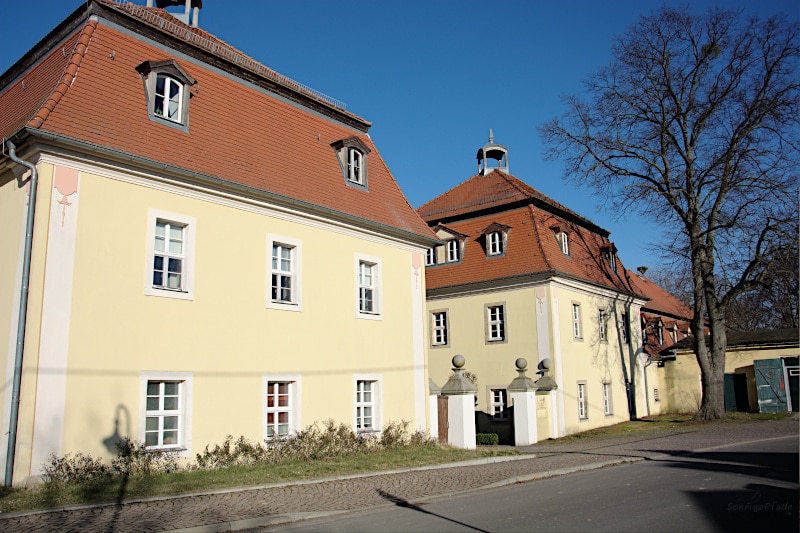
There is not too much to see in Hohburg. But next to the church, the „Steinarbeiter Haus“ (Stone Workers‘ House) as a museum of mining history attracts visitors every afternoon from Sunday to Thursday (1 to 4 p.m.). Because around Hohburg the solid resources of the region were and are mined in several quarries and processed to chippings, gravel or quarry stone. The already mentioned kaolin – mining was another form of mining in the area. Of particular interest is the small technology park with a crane system, steam roller and tipping lorry train behind the stone worker’s house, which is sure to delight children. In the street behind there is a large children’s playground for families to rest.
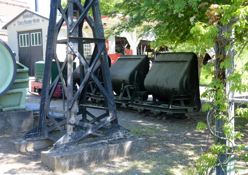
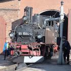
Tipping – lorry – train of stone workers
The mountain range of the Hohburg hills
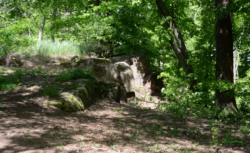
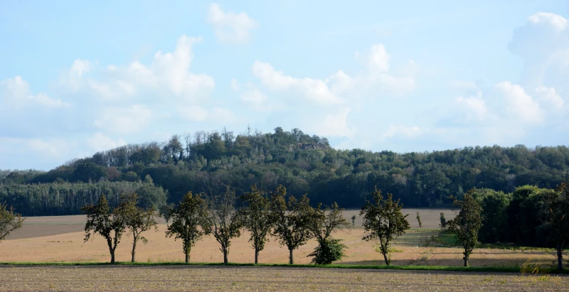
North of Hohburg lie the actual Hohburg Hills – a small mountain range in the lowlands of the „Leipziger Flatlandbay“ with several peaks. The highest hill is Löbenberg peak with 240m above sea level. Behind it are Siebensprung, Zinkenberg, Burzelberg (221m) and Hennersberg peaks, to the village Röcknitz in the north to the Gaudlitzberg (220m) and Steinberg near Böhlitz in the north-west the Holzberg hill. Rock formations appear everywhere, which makes the mountains geologically interesting, especially between Hohburg and Röcknitz. Just along the western slopes there are a number of old quarries, of which only a few are still in operation. Some of these quarries are now water-filled, i.e. „flooded“, such as the quarry at Löbenberg.
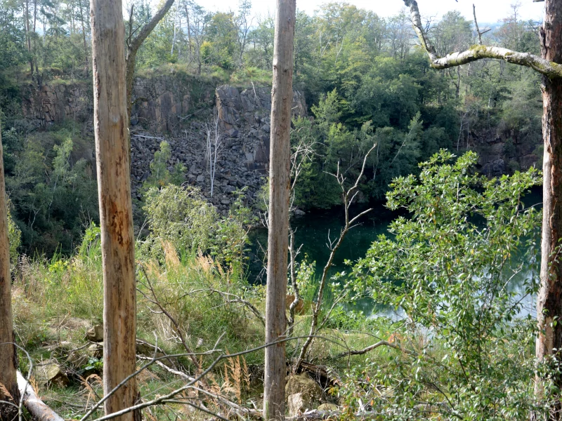
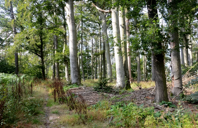
Around the Löbenberg, which rises closest to the north side of Hohburg, beech – pine – mixed forest characterizes the picture. This is not the case everywhere. For example, when hiking on the route from the quarry at Löbenberg to the quarry Zinkenberg, you will find a sparse oak – mixed forest, whose partly gnarled old trees convey an unspoiled character. The storms and drought summers of the last few years have also caused numerous trees to fall or die in the Hohburg hills. Obviously, the forest areas are only partially cleared.
On many slopes, fallen trees, broken dead wood and new growth give the impression of wildness. This is exactly what makes the hike through the forest areas of the Hohburg Hills all the more interesting. For patient, persevering nature observers, there are opportunities to observe animals, especially rare species such as the black woodpecker, especially on quiet weekdays. Since the hiking trails are mostly narrow paths between blackberries, dense herbs and sprouting young bushes, hiking in the Hohburg Hills becomes an adventure of discovery. However, sufficient protection against ticks and mosquitoes* and, if necessary, tick tongs* are highly recommended.
Hiking and tobogganing – when there is snow
In the Hohburg Hills you can hike in a beautiful and relaxed way – in other words: take long day walks. Refreshing mixed beech forests provide shady walks on the various trails. Individual hiking routes in the Hohburg Hills are marked. A Hohburg circular trail is designated as well as a (longer) mining nature trail.
On the southeast slope of the Löbenberg there is a toboggan slope – in case of snow. In the 50’s there was even a ski jump on a northern slope of the Hohburg Hills, but it was already in ruins when I hiked there in my childhood days in the early 70’s. Elevated curves on some paths testified to the former use as a luge track. But even fifty years ago there was a lack of sufficient snow and long-lasting winter weather. Since the area is not too big and well signposted, you can simply walk on it. If you are unsure, a previously saved waypoint in your GPS phone will of course help you for the uncomplicated way back to your bike or your accommodation.
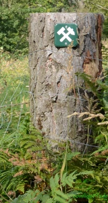
Currently, with a little luck, you can get a small hiking map „Hohburg and its Hills in the Geopark Porphyrland“, which is published by the municipal administration Lossatal, in the Stone Workers House, at the Citizen’s Office or, for example, in a flyer – dispenser at the parking lot (at the area map „Lossatal“). On the front side there are further tips in German for visiting the region as well as information about the museums „Steinarbeiterhaus Hohburg“ and „Heimatmuseum Großzschepa“. The hiking map covers the mountain ranges at Hohburg and Kleinzschepa. Of course, the designated hiking routes through the Hohburg Hills are highlighted on the map.
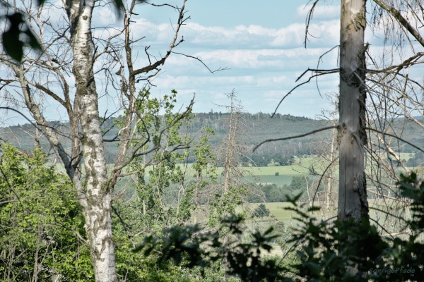
For those who only want to make a short round in the village, the circular route of 3.3km is recommended. At 7.1km, the mining trail, which begins at the Hohburg stone workers‘ house, is considerably longer, but definitely worthwhile. This leads past the Löbenberg quarry, then crosses an oak grove and meets the Zinkenberg quarry in the north. The way back leads past the Löbenberg. If you want to „climb“ the summit plateau, you have to make a small detour on both loop trails. However, the mountains do not offer a real view, since the summits are forested. Long-distance views at Hohburg are only possible from the Kleiner Berg and from the slopes below the forest borders.

Climbing in the quarries with „Mountain Film – Festival
The walls of the quarries in the Hohburg Hills have been attracting climbers for climbing since the 1920s. There are about 200 climbing routes, some of them very difficult, which have changed in the last decades, also due to the continued operation of the quarry. Once a year a „mountain film – festival“ takes place in the quarry at Gaudlitzberg near Röcknitz. Supported by the local mdr – broadcasting station and organized by Saxon mountaineering clubs, various films are shown by mountaineers and hikers.
Extend and lengthen the tour from Hohburg
So the Hohburg Hills are a perfect destination for a day or weekend – trip especially from the Leipzig area. Then the journey remains short and enough time for adventure. Small mountain, big round hike, visit in the stone worker’s house, bathing in the kaolin lake… so a weekend passes like in the flight.
But some would like to extend their stay in the countryside. Especially those who really want to hike will quickly leave the Hohburg Hills behind. Or too quickly removed as a cyclist…

Then, first of all, the connection with the nearby Schildberg Hill (217m) and the small town Schildau is recommended. This is at the same time a western gateway to the Dahlen Heath (Dahlener Heide), which begins with the Schildberg Forest in the west. And several days can be spent there.
If you are on foot, you can hike from Hohburg over the Burzelberg and the „Klinge“ near Zwochau village and from there over Kobershain village to the Schildberg (S-Way, from Zwochau marked with a red bar). This path leads as good as always over pleasant forest paths and quiet field paths. By bike you can go along the less frequented roads from Hohburg to Thammenhain and from there either via Kobershain or directly to the Schildberg Hill. The hiking map Dahlener Heide – Wermsdorfer Wald helps to orientate in the whole region (see below).
East of the Dahlener Heide again runs the Elbe cycle way and thus still an attractive long-distance bike path to continue … at least to the next station.
Geopark North Saxony – Hohburg, Röcknitz, Schildau
The Museum Steinarbeiterhaus Hohburg belongs to the four „Geoportals“ of the region, which act as „Geopark Nordsachsen“. For the designation as „Geopark – Region“ speak the many outcropping stone formations around Hohburg and also the mining – activities, usually as quarries. Beside Hohburg the „Geoerlebnisgarten“ (geo-eventgarden) in Röcknitz (same mountain range, northern wheel of the Hohburg Hills) and the city Schildau are counted to it, whereby here the Schildbürger and Gneisenaumuseum counts as contact for the Geoportal.
However, the geo-topic plays a rather subordinate role in Schildau – the Schildbürger (Schilda citizens comparable „The wise men of Gotham“ in UK) with their pranks dominate the interest, followed by the prussian army officer Gneisenau, who was born in Schildau in 1760. Nevertheless, the surroundings of Schildau offer some geological „hotspots“: The Schildberg (217m) is basically an eastern offshoot of the Hohburg Hills, also with volcanite – quartz porphyry – rock from the new red conglomerate. In the surroundings of the Schildberg there are several small quarries (abandoned) as well as on the southwest slope the „Napoleon stone„. There were also several clay pits in the vicinity of Schildau (today partly water bodies), the clay was pressed into bricks and fired in the Schildau brickyard until the seventies.
Travel tips for the Hohburg Hills
[Contains *advertising]
The weather in Hohburg
A current weather outlook for your hiking days in the Hohburg Hills can be found in the adjacent chart. The weather outlook for today and the next three days makes a weekend trip to the Hohburg Switzerland weather-technically calculable.
Since the „Hohburg Switzerland“ can be reached quickly at least from the Leipzig and Halle area, you can set off for a hike quite spontaneously if the weather is promising.
The varied hiking routes are also nice to walk in friendly autumn and winter weather. There are no difficult climbs where you have to fight your way through ice and snow. So you can also hike in the surroundings of Leipzig without having to make a long journey.

Journey to Hohburg
By train and bike
By train* from Leipzig the easiest way is to take the local train S3 or Saxonia Express to Wurzen station and then by bike via Lüptitz on bike paths to Kleiner Berg and Hohburg. If you want to vary the way back a bit, go from Hohburg to Röcknitz (northern edge of the Hohburg Hills) and then via Mölbitz about 6km to Doberschütz station (northern curve of the S4 local train). All via small country roads with little traffic.
If you are traveling with a pedelec (electric bicycle), you will find a free charging station in Hohburg at the corner of Th.-Müntzer – street. Unfortunately, hidden behind a canopy in front of a large apartment building (diagonally opposite the Linden pharmacy) and without further signs. Standard usb-devices like smartphones can be charged there as well, there is a connection for usb-cables with storage in each charging box. The box is lockable with its own padlock*. Beside there is a manual pump for bicycles.
Theoretically, you can travel from Leipzig by bike, since Hohburg is located on the Leipzig-Elbe cycle path. Practically, however, I would prefer to take the S – suburban train out of Leipzig and only get on a bike in the quieter regions. Bicycles can be taken along free of charge on regional and suburban trains in the area covered by the mdv traffic association.
With car or caravan to Hohburg
By car or rental car* from Leipzig or Dresden on the B6 main road to Wurzen, from there via Lüptitz to Hohburg. A large parking lot including a caravan* site is located in Hohburg in the middle of the village in the valley of the Lossa. There is also a power supply for motor homes with the german CEE-blue socket (caravan socket). Further parking possibilities are at the Kaolin lake, especially for bathers, at the Konsum Hohburg grocery as well as at the Steinarbeiterhaus for visitors of the museum.
There are further parking facilities at the Kaolinsee, especially for bathers, and at Konsum Hohburg.
One of the parking lots at Kaolinsee is located directly on the road „Am Lossatal“. But there is also a parking lot in the countryside behind the „Am Kaolinsee“ bungalow development with direct access to the beach and a state-of-the-art toilet block. From both parking lots, it is possible to take a walk around the Kaolinsee Hohburg as well as a short hike to the nearby Kleiner Berg, even without having to cross any other roads.
For direct access to the nature reserve on the „Kleiner Berg“, we recommend the relatively large parking lot at the Hohburg sports field. This can be reached via Jahnstraße. From the parking lot, it is also not far downhill to the Birkenbuschin café.
Supply before the hike in the Hohburger Hills
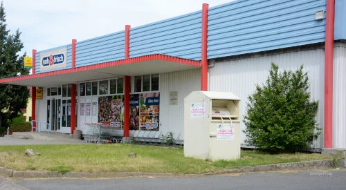
Unfortunately, a somewhat more difficult issue. Take your own food with you. There is a inn „Zum Lossatal“ on the corner of Th.-Müntzer-street / corner Am Lossatal. Whether open and how varied the food offer is, rather questionable… Otherwise at normal opening hours (MO-FR 09-18, SA 09-12) the former Konsum grocery, which ensures the minimum supply for the village population under the brand name „nah und frisch“ (near and fresh).
Next to the former cultural center „Zur Hohburger Schweiz“, the outwardly inconspicuous Victorian Café Birkenbuschin invites you to enjoy a sweet afternoon meal during the warmer months of the year. It is open from Thursday to Sunday and on certain public holidays. There is a small parking lot at the edge of the green area opposite (with a map of the Lossa valley and a flyer dispenser „Hohburg and surroundings“ – hiking map). The somewhat strange name of the Cafè Birkenbuschin goes back to a foundling, Johanna Dorothea Friederica Birkenbuschin, who was picked up below the Kleiner Berg in May 1770. The surname truly describes the place where the girl was found and where she was soon baptized.
The Café Birkenbuschin is also a good address for collectors of antiques, as the furnishings of the Café are sold for a reasonable price.
Only who is anyway in the direction of the east (Dahlener Heide) further on the way, finds in Schildau then with restaurant and pizzeria „La Cabane„ (former Toscanella, Wurzener Street below the Kirchberg (church hill)) and the new ice cream parlor „Zum Schildberg„ (Friedensstreet 13 – on the way to the Schildberg hill) again something more at gastronomic facilities. The ice cream parlor is open seasonally (approximately from Easter to October) and offers not only ice cream but also coffee and cake as well as a midday snack.
Accommodation in the vicinity of the Hohburger Hills
Apart from a few private rooms, the nearest accommodation in the vicinity of the Hohburger Hills is in Thallwitz, about 5km west of Hohburg . From there, the S-Bahn station Eilenburg Ost (S4 to Leipzig) can be reached relatively quickly by bike.
The room rental at the Holzberg* in Thallwitz offers several double rooms as well as a family room in a wood-clad two-story building with terrace and garden. Here you can also have a barbecue. There are outdoor play facilities for children. Storage facilities for bicycles are available. All rooms have microwave, kettle and coffee/tea utensils. Pets are not allowed.
The Haus am Park* in Thallwitz – Lossa has two spacious apartments. The kitchens are equipped with microwave and coffee maker. On request, the room hostess will provide a breakfast „basic equipment“ for guests arriving late. Bicycles can be borrowed free of charge on request at the house. Fireplace and grill in the garden can be used, also the terrace attracts . Pets are not allowed.
Especially if you want to continue to the Schildberg hill, Schildau and perhaps to the Dahlener Heide, an accommodation in the castle Kobershain* is very well located. From Hohburg it is 6.3km further way there, Kobershain is located west below the Schildberg. A family room and an apartment are available. Breakfast is part of the offer. Rooms include a kitchenette with a toaster, microwave, stovetop and refrigerator. Pets are allowed at Kobershain manor.
If you are already traveling from Leipzig or at least from Taucha eastward by bike along various dirt roads, you can already find exquisite quarters in Püchau – still west of the Mulde River – in the Igloo Hut Molino*. This wooden dome has sauna and(unheated) pool. A living room, kitchenette, separate bedroom for 2 persons and shower bath offer a special stay. The garden can also be used. Igloo Hut Molino is a non-smoking accommodation. Pets are not allowed. Near Püchau there is a pedestrian bridge over the Mulde River. However, the use of the bridge by bike is somewhat strenuous, as steep stairs lead up to the bridge on both sides.
Very good accommodation can be found in Heyda, east of Hohburg. For hiking Heyda is not so convenient, because there are only roads as a direct connection. But if you are on the road by bike or anyway with a car, then the about 8km are quickly done (Via Müglenz and Falkenhain). And from Heyda you can go hiking in the southern Dahlener Heide or visit the Wermsdorfer Wald and the electoral Saxon hunting lodge Hubertusburg in Wermsdorf, one of the largest baroque hunting lodge complexes in Europe.
The manor house in Heyda offers two separate vacation homes – the Villa Rosencottage* and the Villa Rittergut*. The location on the manor farm is wonderfully quiet, behind the Villa Rosencottage lies the Heyda Lake and on the farm there is a separate children’s playground. Both villas are exquisitely renovated and have self-catering kitchens. There is enough space for up to four guests each. In the Villa Rittergut you can make yourself comfortable in front of the fireplace on cool evenings.
A hiking and biking map

Since the Hohburger Hills are quite small, there are no real maps to buy except for the above-mentioned free hiking map of the Lossatal municipal administration. Of course, you can pick out the appropriate official topographic map and use it. If you want to explore the saxonian region east of Leipzig anyway in a larger radius as a hiker or with the bicycle, it is worthwhile to purchase the German „Radwander- und Wanderkarte Dahlener Heide, Wermsdorfer Wald und Umgebung*“(Hiking and Cycling map Dahlen heathland, Wermsdorf forrest and surroundings) from the Barthel – edition in the scale 1:50.000. This contains the above mentioned arrival point Wurzen, the Hohburg Hills, the connections to the Dahlener Heide and the connections e.g. in the direction of the Elbe river cycle way or Mulde river cycle way.

Enthusiastic about the Hohburg Hills?
Then share the link to the post in your social media channels and invite your friends to the hike in the „Hohburger Schweiz“. Thank you!
Interested in other geological spots?
Then visit for instance the Hill church Beucha near Leipzig, situated on top over the Church Quarry

Hike to the nearby Schildberg hill with watch tower and quarries
* Reference to advertising – links
Some links are marked with *. These are so-called affiliate links to online – retailers or booking portals. If you click on such a link and buy something in the store, I receive a small commission, which I can use for the design of this blog. Nothing will be more expensive for you, because the commission has already been taken into account in the pricing.
Source of product pictures: Producer/ vendor